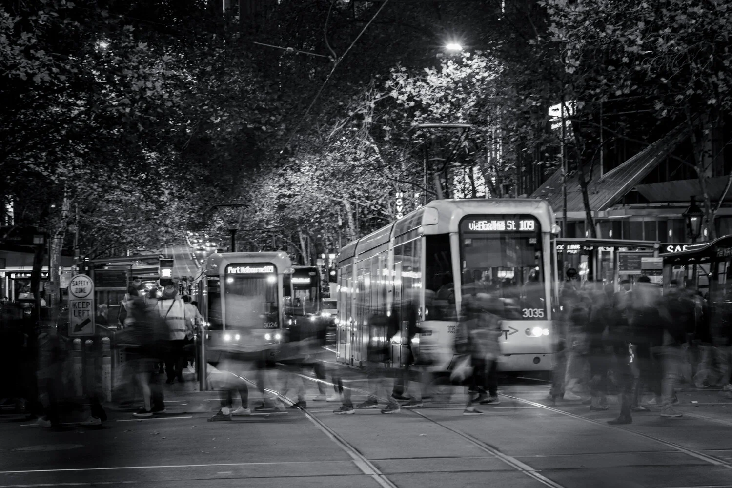
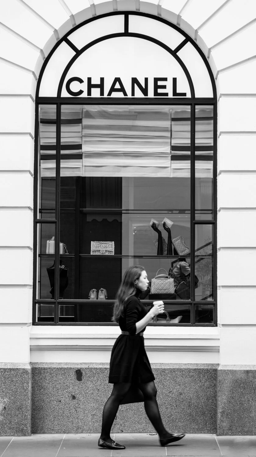
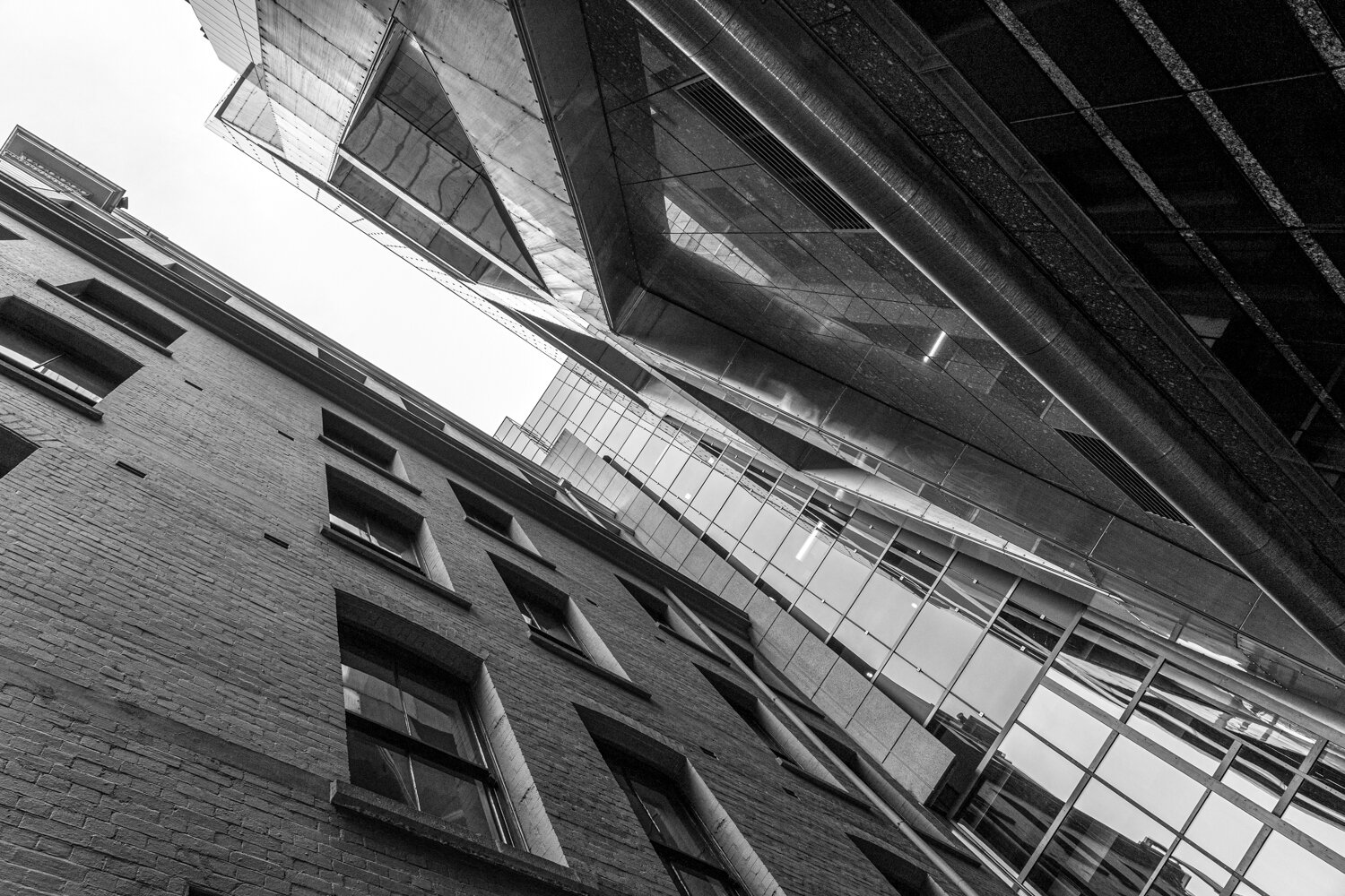
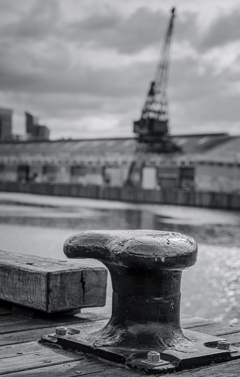
My daughter was luckily to be selected to the Nationals in Gymnastics this year so we flew to Melbourne for the event. A good excuse to take the camera along to capture not only the gymnastics but a little bit of the city as well.


April 2019: Dunn's Swamp, NSW
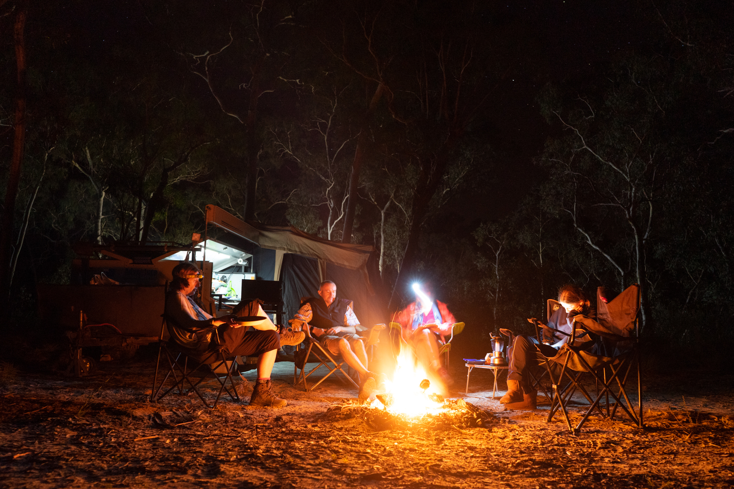
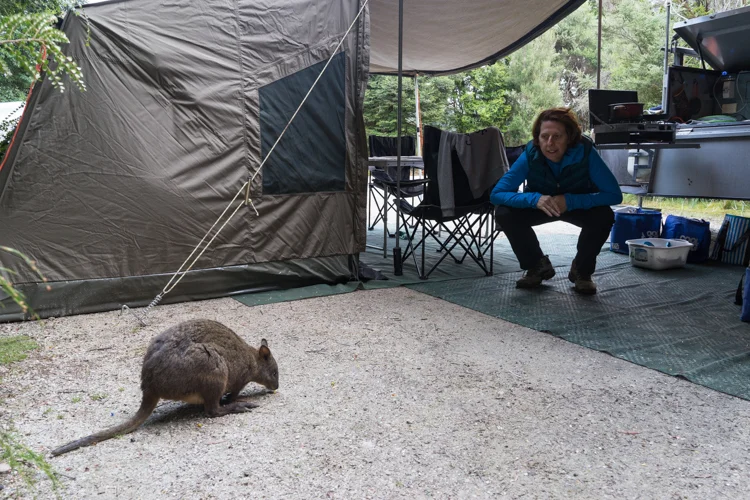
It’s been a long time between drinks with limited travel due to work commitments.
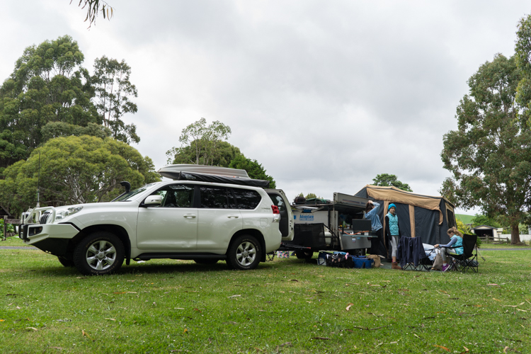
It was finally time to dust of the camper and get some dust put back on it as we headed away for the weekend to Dunn’s Swamp in the Wollemi National Park.
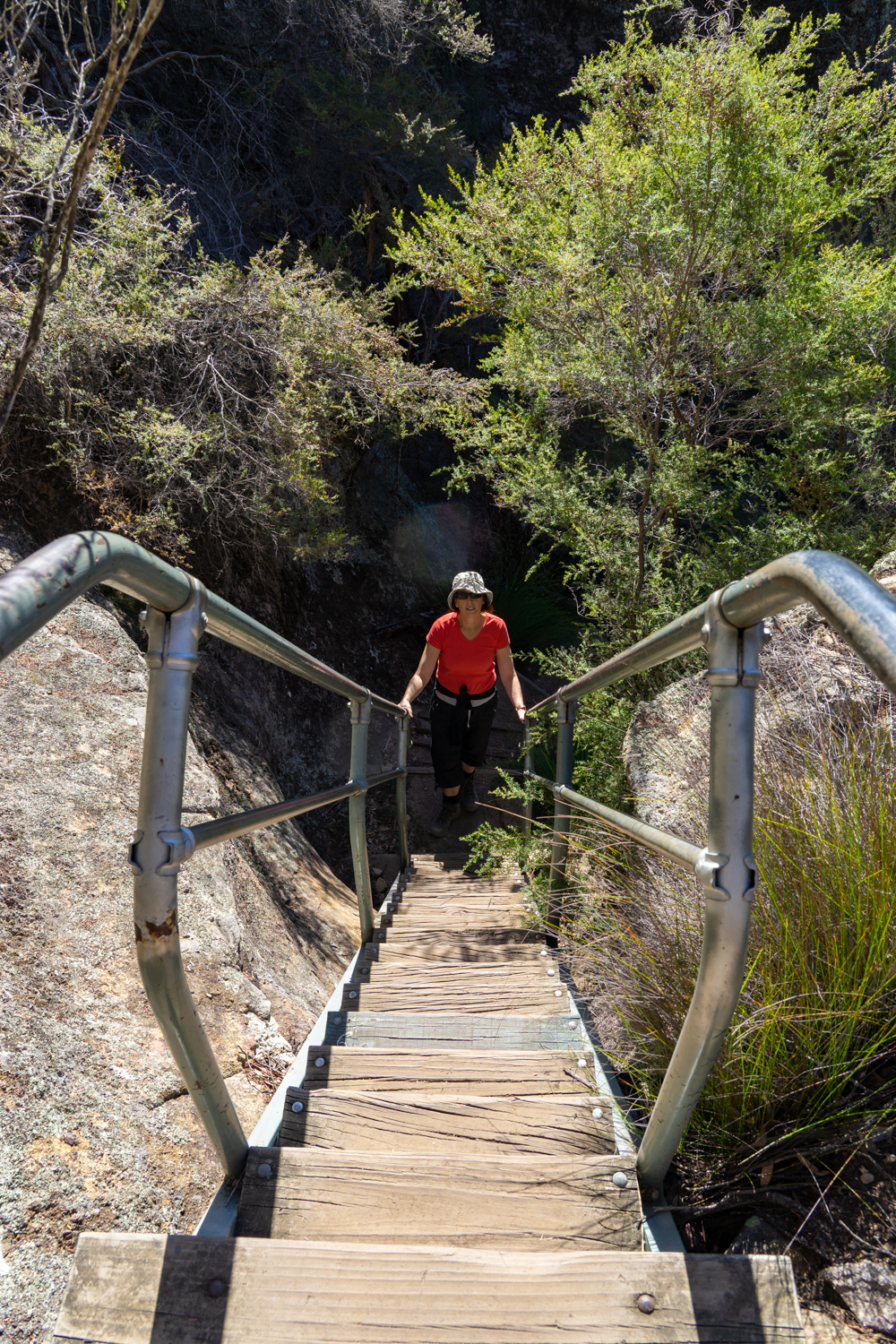
Wile the National Park has some remote areas, one part that is easily accessible, even in a normal sedan, is the Dunn’s Swamp - Ganguddy Campground. Located not far from Lithgow there are approximately 80 spaces to choose. However be warned as many sites are only for tens so, if you are like us, it pays to get there early during school holidays to get a spot for the camper. Tip: you will soon be able to book online so check the NPWS website.
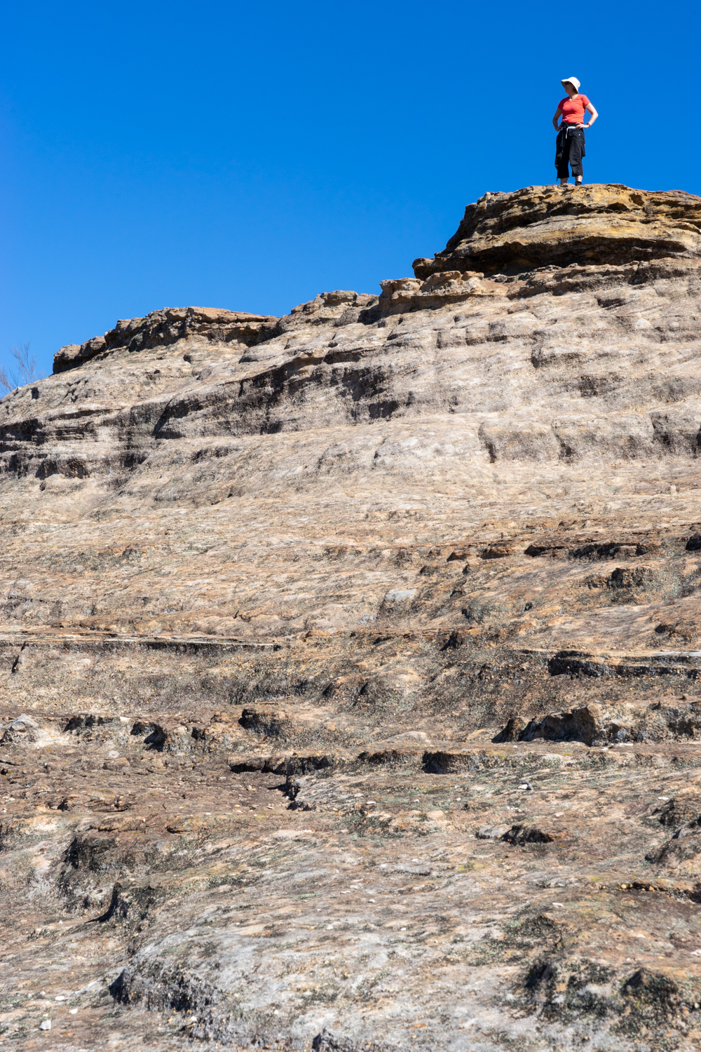
There are a couple of small walks (1 hourish) including the Weir Walk and Pagoda Lookout which provided panoramic views over the Cudgegong River and surrounding volcanic outcrops.


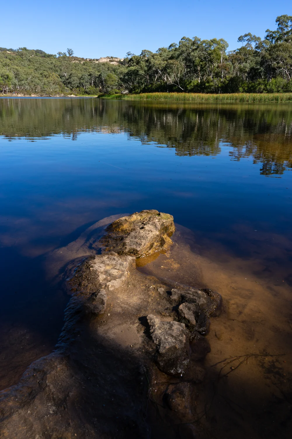
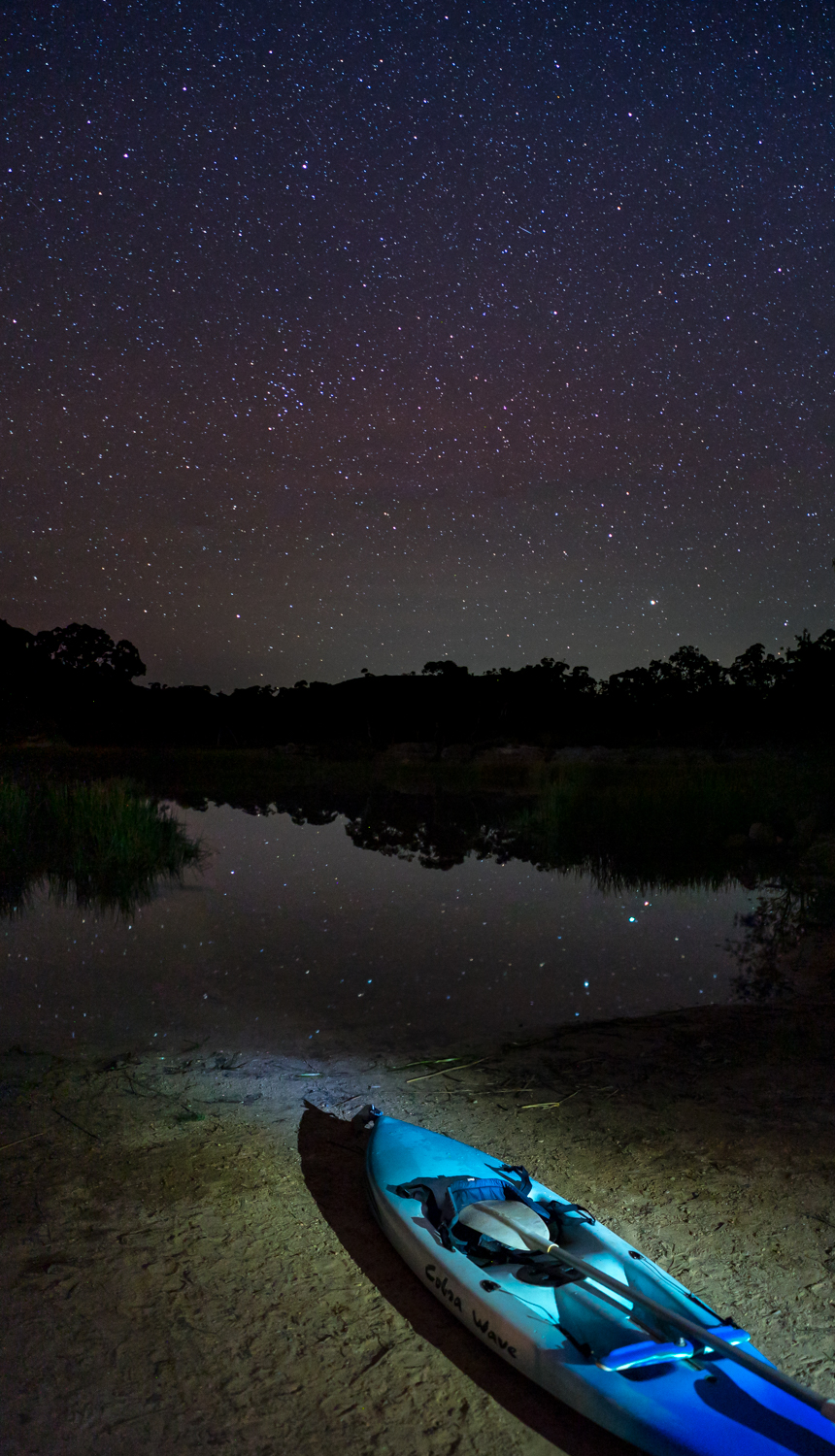
But one of the main reasons to come here is to paddle on the swamp. The good news is that it is actually a lovely lake formed due to the construction of the Kandos Weir. This was constructed in the 1920s when the river was dammed to provide water for a cement works.
We spent the weekend paddling past purple swamp hens building their nests in the reeds, and black cormorants fishing from the rocks. And if you are very lucky like I was, you may get a chance to sight a platypus on the water edge (no photo unfortunately).


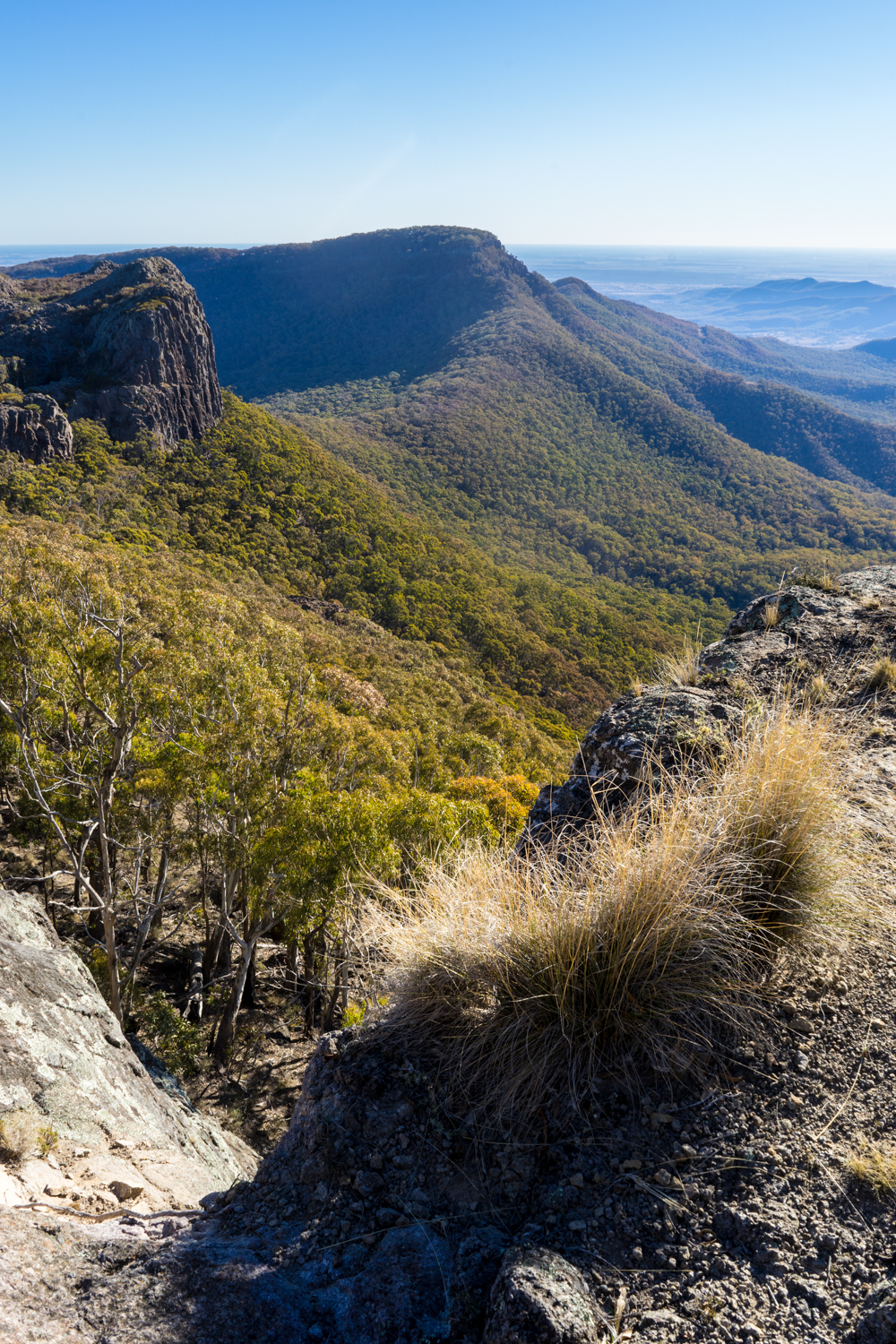
July 2018: Mount Kaputar, NSW

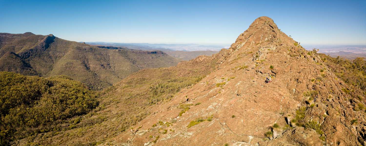
What do you do when they are expecting the coldest July weekend for the year - You head to a Mountain! Mount Kaputar to be precise, in central NSW. The National Park is located about an hour from Narrabri so our chances of camping alone when the chill factor would get well below zero were high.


The Nandewar Ranges are an extinct volcanic range created between 17 and 21 million years ago. What is left of these volcanoes now provide an amazing walkers paradise with panoramic views from many of the peaks.
The Yulludunida Walking Track is a hard 4km return hike which starts at the Green Camp car park. The first part of the walk is a constant climb up a well formed stairs through the woodland. Once you reach the base of the Yulludunida 'crater' it open up to an amazing rock summit. From this point you follow the stone cans with some near vertical climbs up the rock face. There were definitely point that I was thinking - i hope no one falls as there is only one way out and that is via a chopper.


The Corrunbral Borawah walk is an easy 2km return that begins at The Governor carpark. From hear a open track takes you to the top of The Governor with more amazing views over the range.
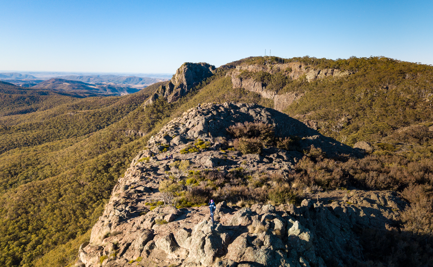


From Dawsons Springs camp area there is a, easy 6km round trip hike that takes in a range of lookouts. Eckford Lookout overlooks the southern part of the park and Lindsay Rock Top, a strange open rocky lava flow, both having spectacular views over the surrounding agricultural plains. The day of our walk didnt get above about 5 degrees but luckily there was not a breath of wind.


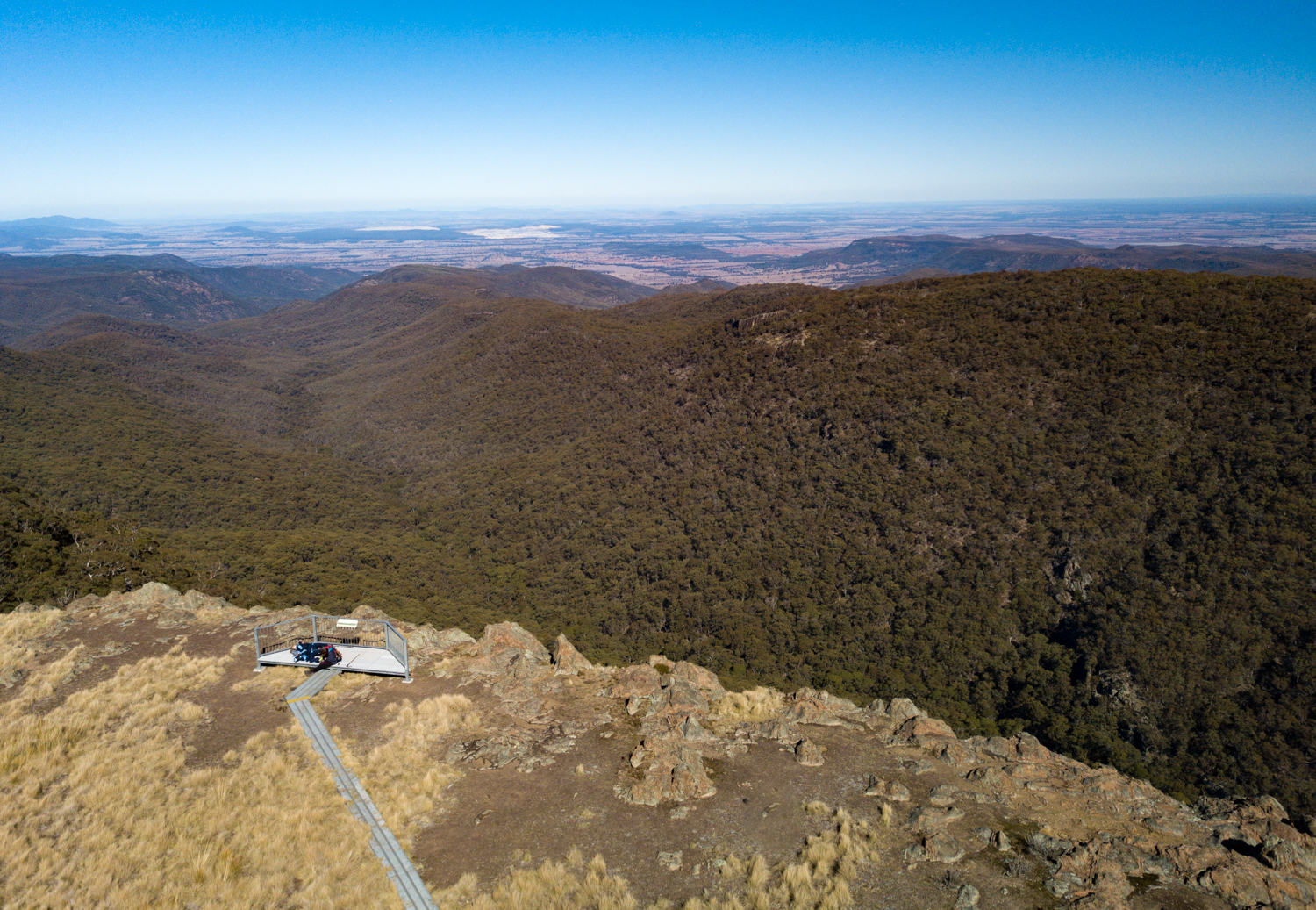


While Mount Kaputar is the highest peak at 1512 metres, it is the easiest to access with a short 4WD track to the peak and a viewing platform to make life easy.


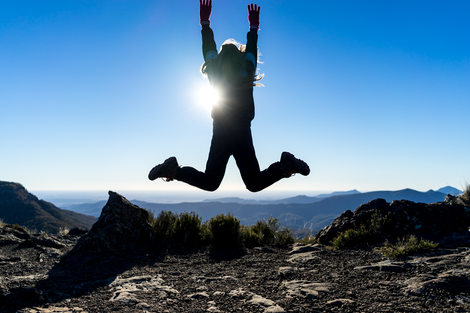
Probably the most frustrating bit of the trip is when you drive for 8 hours looking forward to some dark night skies and you realise you have forgotten your tripod! The best I could do was one shot with the camera on the ground.

If you plan ahead you can also get a key to access the Barraba track which climbs from the small town of Barraba on the eastern side of the park.


A short video from the trip
One track Mind: A Trip along the Frenchmans
While I have not had a chance to get up to Cape York recently the following story was published in the May 2018 Issue of 4WD touring Australia.

Sitting at Moreton Telegraph Station we were having a well-earned rest having recently reached the Tip of Cape York. A grey nomad sitting near me excitedly remarks to his partner, “I just heard that it took someone 6 hours to do the 50km stretch and another person flooded their car in the Pascoe”. It was looking like our fun was not over yet.
Most who make the pilgrimage to the tip have one track in mind. The Telegraph Track. And while the ‘Teli’ is famous, there is another less travelled track that is one of the Cape's most testing – The Frenchman. The Frenchmans Track is a ‘shortcut’ (in distance not time) from the Peninsula Developmental Rd to Kutini Payamu (Iron Range) NP.


Contemplating what I have just heard, I read over the 4WD rental agreement one more time. The good news is that it does not say we can’t go on the Frenchmans. The bad news is we have no winch. At this point I begin to question the decision to hire a 4WD rather than drive my own car all the way to the Tip. But, like many, the ability to take enough time to travel from one side of the Country to the other was not feasible.
Having flown to Cairns, we hired a 4WD with the aim of exploring as much as possible in the short time we had off. While the thought of trying to explain why we turned the rental into a submarine was not pleasant, there was no turning back.
Leaving Moreton Telegraph Station we head south looking for the small turnoff, having been told it can easily be missed. Sure enough, we miss it. Turning around we spy a sandy track deviating off in to the open forest. After a short drive the tree canopy begins to close in, the vegetation doing its best to remove the dirt scar through its heart. We soon realise that the lush green canopy is accompanied by what was to be the first of many bog holes.
The term ‘bog hole’ does not do them justice, as the reality is, they are really long, watery slush pits. While we do our best to test how deep it is, the distance makes it impractical, and no one volunteers to walk their length. While sensibility would have us turn around, with plenty of right foot and turns of the wheel, we power through each of them, hooting at the end of each one. This was fortunate as the lack of a winch or maxtrax (sitting comfortable at home on my own 4WD) would have made it a very slow dig.


After 12 very slow km we reach the Wenlock River and the next real test of what a stock 4WD can really do. The trusty landcruiser drops down the steep rutted entry to Wenlock River with only a few heart palpitations being caused. I am definitely glad I’m not going up the other way. The base of the river is firm with water lapping the top of the tyres. “This is not that bad after all”, I think, as I slowly get lulled in to a false sense of security.
From here, a mix of sandy, rutted and open tracks provides all manner of variety keeping the drive fun. However the smile is quickly removed as we stop perched at the top of a bolder strewn drop off. I stare down into the Pascoe River, and the thought of our conversation back at Moreton. Unsure what frightens me the most, the rock littered track or the depth of the flowing river, I take one last check of that rental agreement again.
Throwing caution to the wind, I thrust it into 1st gear low range and descend over the ledge. The stock cruiser, wanting to show of to the growing congregation, works its magic descending the track like a ballerina hoping lightly from one ledge to the next.
Like all river crossings up the Cape the level of difficulty is proportional to the amount of rain. However the Pascoe is deep most of the year with large rocks hidden under water ready to destroy a diff if you pick the wrong line. This is one crossing that must be walked to locate any deep holes ready to test out the insurance claim. With a mix of power, low tyre pressure and fingers crossed we part float, part lurch to the other side.
It is not over yet with a steep exit so we point the nose to the sky and hang on tight. Coming to a stop at the top, the blood begins to return to the knuckles griped around the steering wheel like a boa constrictor snake. The grin of both relief and exhilaration returns to the face knowing that I won’t have to do any explaining to the hire company.


From here we cruise along the white sandy heathland, grey termite mounds standing like soldiers on either side celebrating our success. We eventually join Portland Road and make our way to Iron Range National Park with a quick stop at Lockhart River for supplies. Lockhart is famous for the Lockhart River Art Gang, where you will find a studio with local artists producing paintings, basket weaving and other traditional craft works.
Back on the road, Iron Range National Park lives up to its name with its yellow and red rocky escarpment. While early travellers came here in search of another yellow mineral following the discovery of gold by John ‘Jack’ Gordon in 1934, the modern day traveller can enjoy bird watching in one of the largest remaining area of lowland rainforest in Australia.
However our aim was to see if we could spot one of the much rarer green pythons the area is famous for. Heading out for a walk along one of the tracks at night, we have been told the pythons are sometimes seen curled around branches overhanging the track ready to catch any unsuspecting dinner morsel. The torch catches glimpses of red from the reflecting eyes of the crocodiles looking at us as a possible dinner morsel. Having walked for 15 minutes I am surprised to see what looks like a rubber snake directly in the middle of the track. As we approach the plastic snake begins to move. It seems luck was on our side, not only getting through the Frenchmans unscathed, but seeing one of these majestic creatures in the wild.


Having spent a few nights at Chili Beach with its postcard palm lined beach, we return to the Peninsular Development Road. Crossing the Pascoe river again, this time a much easier ford, we re-live the excitement of the previous few days.
Our last stop is Rinyirru (Lakefield) National Park. During the wet season this low-lying area becomes an inland sea making it completely impassable. But during the dry, the numerous wetlands and streams come alive. Surrounding the Lakes, the Nifold Plains are an endless sea of tall grass interspersed with hundreds of termite mounds. Camping by one of the numerous Lily covered Lagoons we watch the magpie geese and sarus cranes search for breakfast amongst the red lotus flowers. It is advised not to get to close to the edge for risk of ending up breakfast for the crocodiles that also inhabit the wetlands.
Our last camp is at the Old Laura homestead, a great spot to relax and share the stories of conquering the Frenchmans in a stock fourby. While many put off visiting Cape York due to the distance to get there, the idea of hiring a 4WD may just be the ticket you need to experience this part of Oz. ….But just remember to check the rental agreement before you take the plunge.


May 2018: Branxton Rodeo
May saw a trip out to the Branxston Rodeo in the Hunter, NSW. While many of them are amateurs they still know how to ride a bull.


If the riders were crazy, they are not as mad as these guys who put their body on the line to protect the cowboys.


They also manage to have a bit of fun despite the dangers.


But there is a whole lot more at the rodeo than bull riding. There is some amazing horsemanship as cowboys and cowgirls put their horses to the test.


What I also love about events such as these is it does not matter the age, everyone gets involved.


April 2018: Kangaroo Valley, NSW
Not many photos from this trip as i was under strict instructions. It was our wedding anniversary. Despite this we did manage to get out and explore this great part of NSW and I snuck in a couple of images.


April 2018: Booti Booti National Park, NSW
Easter, so what better time to get away. This time to Booti Booti National Park. I did a story on this in an earlier issue of 4WD Touring which made me decide to venture back.
If you want to escape the crowds this is definitely NOT the place. they pack them in here and there were lots of parties going on so be warned.


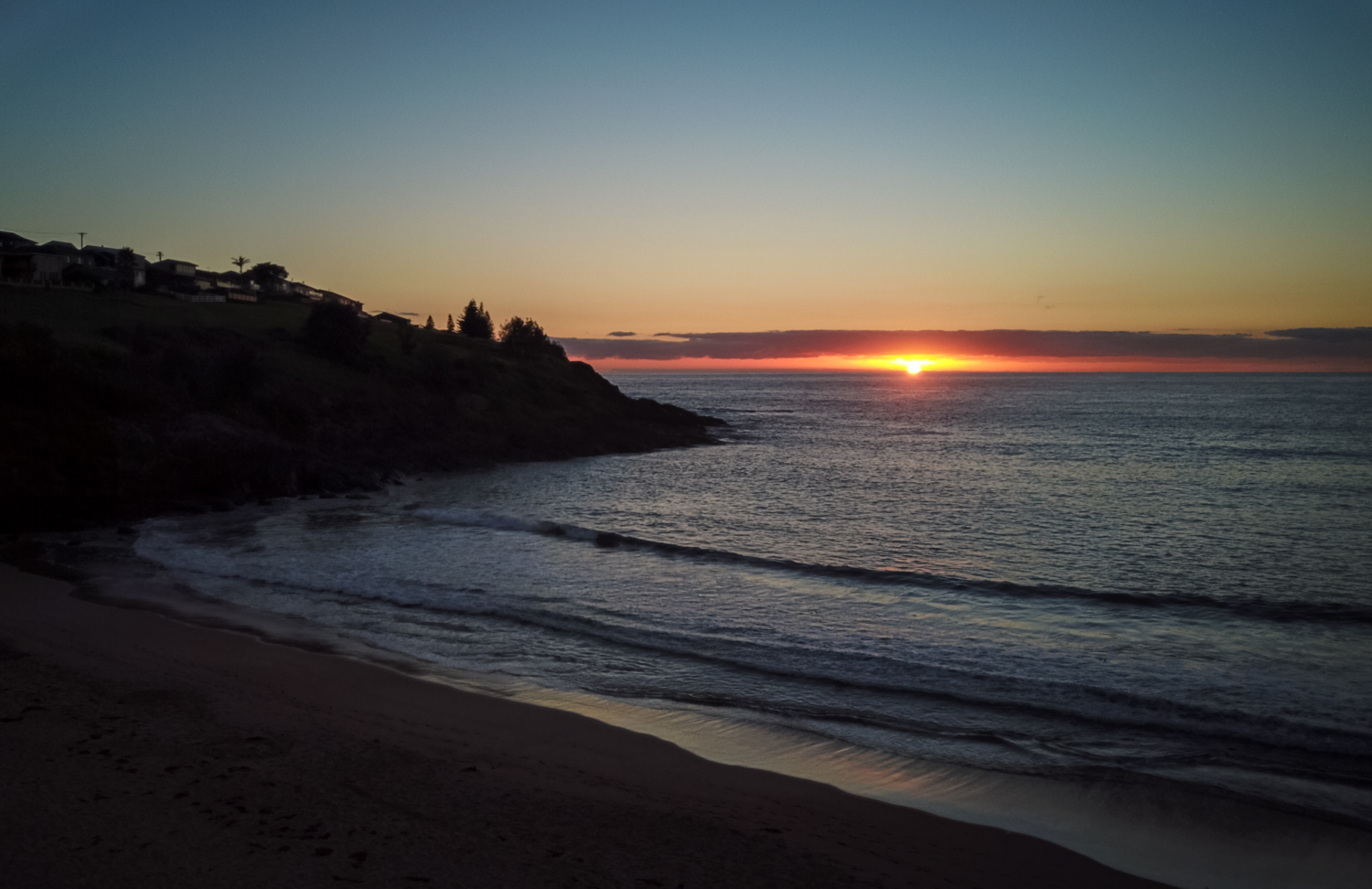
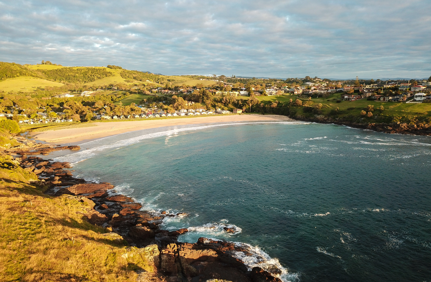
February 2018: East Beach, NSW
A weekend away with friends to East Beach near Kiama saw lots of drinking but not much photography. However I did escape for one early morning shoot.

While the camera did not get much of a work out i did have another play with the drone. Still getting used to to making the most of this new toy.
October 2017: A Different kind of Roadtrip - USA
While this site is largely dedicated to travelling throughout this great land called Oz i was fortunate enough to escape for a short trip to the US of A. So what better excuse to do a quick road trip through California, Arizona and Utah.

Not a bad way to see..
The might US of A.
If you are going to do a road trip in the US it has to be in one of these.


While the aim was to spend some time in the National Parks, i could no miss the opportunity of travelling along part of Route 66. While Australia has some great stretches of road i can see why this has entered in to US folklore.


The first experience of Zion National Park was entering via the scenic byway. Completed in 1930, this is considered one of the great road-building accomplishments at the time. Heading down into the valley you descend via several switchbacks, passing through two long narrow tunnels blasted through the cliffs. With jaw dropping scenery it is easy to see why this is a hikers navana.
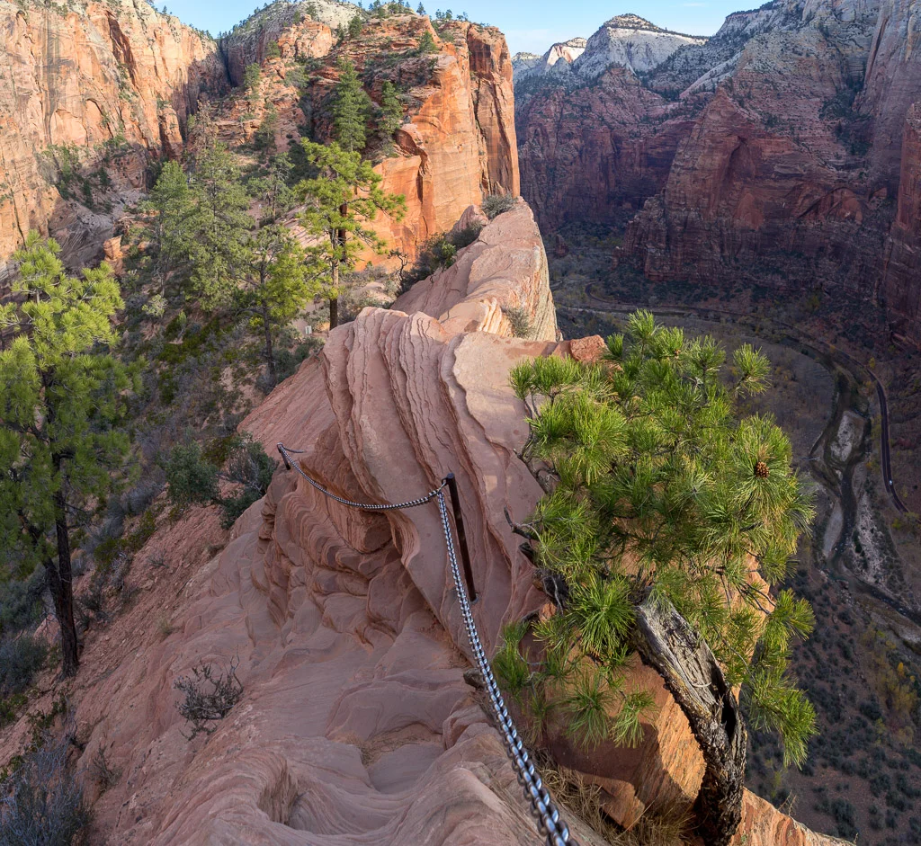
For me it was two hikes, the first being Angels Landing. As the name suggests this hike takes you to what feels like the top of the world.
The first part of the hike follows the West Rim Trail along the river than up a series of switchbacks which appears to cling to the canyon wall. From here it is into Refrigerator Canyon (yes a nice cool section) then some more significant switchbacks, called Walter's Wiggles. At Scout Lookout the sign stating that 7 people have died doing the last section - usually enough to stop most walkers here, especially those afraid of heights. For the brave (or stupid if you include me) the last section of the trail uses chains to follow the ridge (with bottomless drop-offs either side) across a saddle and up the hogs back. The pictures don't do it justice.
The other walk, not as dramatic but just as interesting was Hidden Canyon. With sections of this hike are similar to Angels Landing, it has vertigo-inducing trails and chains to prevent you from falling to the depths below. From here you enter a long slot canyon.


Bryce Canyon National Park is a geological oddity with ancient sandstone cliffs carved into bizarre pillars. The hike takes you down into the canyon and winds its way through the towering rock formations and pine trees. In the early morning the thousands of hues of yellow and orange sandstone mix with the sky.


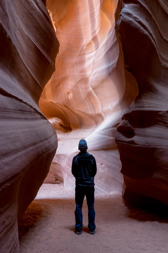
Antelope Canyon is another geological wonder in Arizona. These narrow canyons are formed by water rushing through rock leaving behind a clay sculptures masterpiece. While the solitude shown in the pictures is calming, i was fortunate to be on a specific photographers tour, otherwise you are subjected to a sardine like football scrum full of iphones pointed to the sky.


Horseshoe Bend in Arizona is a section of the Colorado River where the power of water over millennium can be seen at work. It is about a 3/4 mile (need to use miles not km when in the US) walk out to the edge overlooking Horseshoe Bend. There are no barriers (the lawyers have obviously not got involved yet) where you can stand on the edge of the canyon - or sit like this couple.

Monument Valley, Utah, is like a scene our of the Wild West - Actually it is a scene as many movies were shot here. It is also the sacred heart of the Navajo Nation. Ancestral spirits was over the towering sandstone rock formations. Modern day Navajo's also sell their amazing craft so if you want to get something authentic this is the place.
The 17-mile scenic drive allows you to weave amongst the 1,000 feet towers. It almost competes with the endless Australian outback skys and milky way but I must say i do miss the southern cross.


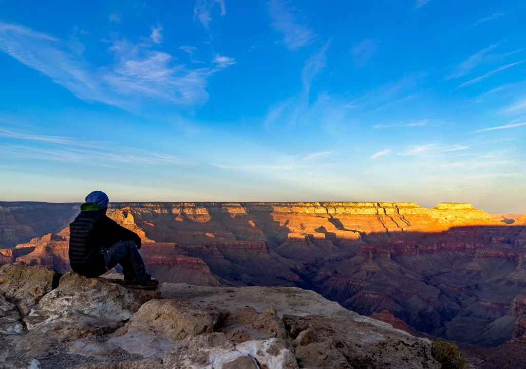
The Grand Daddy of them all is the Grand Canyon. There are not many words that can describe the shear expanse and majesty of this place.
The National Park Website says "DO NOT attempt to hike from the rim to the river and back in one day, especially during the months of May to September." So off I set to hike from the rim to the ..... as far as i could get in one day. Taking the South Kaibab Trail, this steep hike into the valley depths gives view after stunning view. With names such as Ooh-Aah Point it is no wonder. After a long hike down and knowing it would take twice as long doing the tough uphill grind I made it to Skeleton Point (a hint to turn around if i wanted to get before midnight).


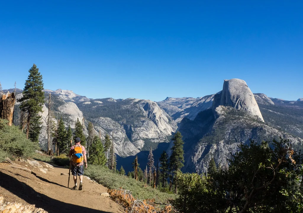
Yosemite National Park is extremely busy but surprisingly if you are prepared to hike it dos not take long to escape the crowds. While it is best known for its waterfalls, Taking the 4 Mile Trail from the valley floor all the way up to Glacier Point to the most amazing view out over El Capitan and Half Dome. From here it was on to Panorama Trail (another 9 miles) weaving back to the valley floor through deep valleys, grand meadows, ancient giant sequoias, and waterfalls. After 21km of walking I deserved a beer at the end of the day.


There is more to Yosemite that the main valley. Heading over Tioga Pass just about every bend in the road reveals another breathtaking view. The pass is only open for a few month of the year due to snow. Tenaya Lake is the largest natural lake in Yosemite. Once you get on the other side of the pass you can drive back along the range. Alabama Hills Natural Arch and the escarpment of the eastern Sierra Nevada were the backdrop to many western movies.


Booti Booti National Park, NSW
This story appeared in Issue 65 of 4WD Touring Australia

When many Sydneysiders think of fleeing the rat race for a summer escape it normally does not take long before they point the 4WD north and head up the coast. Like a moth to light, they congregate on the narrow strip between ocean and land, alternating between beach cricket, sandcastles and seeing who can catch the biggest wave.
As you head north there are a multitude of options from well equipped caravan parks on the coast to more rustic National Parks. And one of the best of these is the water-bound Booti Booti National Park trapped between Myall Lakes and the Pacific Ocean. Located 140km north of Newcastle this stretch of coast is a haven for families on holiday, anglers searching for that elusive kingfish, or surfers chasing the endless summer.
Leaving the Pacific Highway just north of Bulahdelah, the Lakes Way gives a clue to your destination. As the road hugs the edge of the Lake on the left, the coastal rainforest cascades down the hill on the right until they collide together in a long thin sand-spit. This narrow strip of sand is also where you will find the Ruins Campground.
This large grassed area located next to the beach has all the necessary facilities to keep the children and partner happy. It operates on a first-come first-served basis so like many coastal spots, these are often best avoided in the peak holiday periods unless you don’t mind sharing your neighbours music till late in the night.
Here you are spoilt for choice on how to relax with ocean on one side and the lake on the other. For families care must be taken as the beach is not patrolled, but for surfers Blueys and Boomerang are the spot to search for the rolling swell.
In 1818 John Oxley carried a boat from Booti Booti to Boomerand Beach. Luckily you don’t need to carry one that far with numerous spots to launch your boat or kayak in the peaceful Wallis Lake.
And if you want a break from water activities there are several walks including seven mile beach or the shorter, but no less spectacular 3km walk to Elizabeth Beach via Booti Hill. Another scenic walk is Cape Hawke lookout which supposedly offers 360 degree views along the coast from a tower however the tall trees have other thoughts blocking some of the view. And while sunrise is still spectacular, there are more mosquitoes than tourists on bondi beach to keep you company so take the repellent – you have been warned.
The Park is named after “butibiti” the local Worimi word meaning ’plenty of honey’. And while you may not find the illusive golden nectar there are not many sweeter spots you will find on the coast.
Chichester Rock Pools, NSW
This story appeared in Issue 65 of 4WD Touring Australia

While summer often means its time to camp on the coast, unfortunately it also means camping with crowds. An alternative is to escape to one of the great inland swimming holes that lie within easy reach of the big smoke. Chichester State Forest is just 3 hours north west of Sydney near the more famous Barrington Tops National Park and may just be that alternative you are seeking.
You know you are on the right path as you pass ‘Boot Hill’, an oddity of hundreds of boots, thongs, sneakers and even ski boots tied to an old fence. There are numerous campsites to be found in the State Forest accessed from either Dungog or Gresford. The eastern side follows Telegherry Creek with Currawong camping area having a small creek crossing (unless its been raining) usually enough to reduce the number of campers.
The western side follows Allyn River. With several swimming spots along the track, including Ladies Well swimming hole, there are not many better places to take a refreshing dip amongst the forest. And while the summer temperatures may rise to the point of boiling a billy, the creek seems to retain its arctic like temperature perfect to enliven the sensors as you plunge from one of the rock shelves into the black ink pools.
Luckily, unlike many National Parks where there are strict controls on fires and the collection of wood, there is plenty of timber to get the fire cracking to warm up any frost-bite from the days swim. Even better, camping is free.
But summer does not have to be restricted to swimming. Chichester is also a great starting point for exploring many of the tracks throughout the Park. While a topographic map definitely helps, you are bound to find numerous small tracks not marked on any map making Chichester a perfect spot to spend hours exploring and getting the 4WD dirty. Alternatively an easy drive up the windy track to Mount Allyn lookout provides a 360 degree panoramic view over the forest. The ideal spot to watch the last summer rays disappear over the horizon.
Murrumbidgee, NSW
This Story was covered in Issue 64 of 4WD Touring Australia.
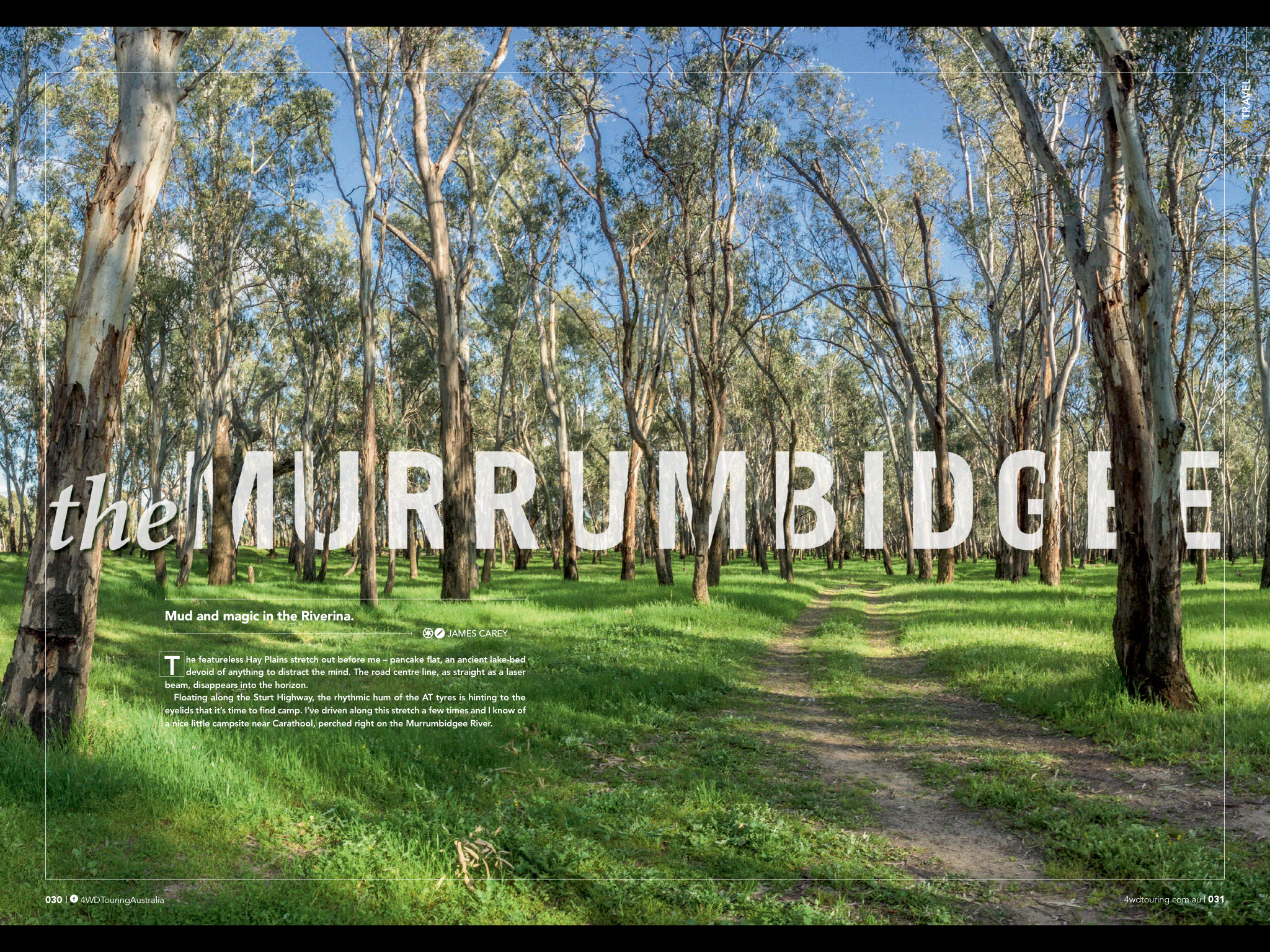
The featureless Hay Plains stretches out before me, its pancake flat ancient lake bed devoid of anything to distract the mind. The road centre line, as straight as a laser beam, disappears into the horizon. Floating along the Sturt Highway the rhythmic hum of the AT tyres begin to give hints to the eyelids it is time to find camp. Having driven along this stretch a few times, luckily I knew of a nice little campsite near Carathool, perched on the Murrumbidgee River.
With the sun dipping below the salt bush, impenetrable darkness quickly takes over with no moon or stars to expose the barren landscape. Almost feeling my way I turn down the dirt track, the thought of a warm fire and my first beer further relaxing the consciousness. As the 4wd crests the large bank to drop down onto the river flat, inexplicably momentum is immediately sucked out of the car and a strange squishing sound emanates from outside.
While the foot presses harder on the throttle, the sluggish brain starts to process what is going on. I had camped here before on the flat dry river bank. I remember the cracked dry mud being a perfect spot to set up the camper. Dry MUD? Hadn’t there been floods through here a few weeks ago? By the time the neurons had computed what was going on I was 10 metres further in to the sloppy thick sludge.
Knowing that I would not be opening the cool ale soon it was time to make a plan. There was no option of going forward as it would only send me further into the abyss so reversing was the only exit. Luckily I had the maxtrax but with the camper on the back even these extractive wonders were going to need some help. The next hour involved the collection of branches, timber and logs within a mile radius to lay a path back up the bank.
Knowing there was only one chance of extraction, and not wanting to take a lonely walk in the middle of the Hay Plains, the shifter was thrust in to reverse. With mud flying and branches spitting out from under the 4WD I slowly inched my way back up the embankment out of the clutches of the river.
I should have known this could happen as the Murrumbidgee is no stranger to flooding with the system relying on its periodic fluctuation of dry and flood. Since first records there have been over 70 floods over 8 metres at this site, enough to put a halt to the best-equipped 4WD.
You can see the Murrumbidgee well before you get there, the towering River Red Gums clinging to the river edge relying on the ephemeral floods to remain healthy. The Murrumbidgee is one of the few locations where dense forests of these majestic trees can be found. These timbers are also home to threatened species such as the Superb Parrot and Regents Parrot, making camping along the river an ideal bird watchers weekend.
The River originates high in Kosciuszko National Park until it spills its soupy brown liquid into the Murray River at Balranald over 1600 kilometres later. The river twists through the land of Ngarigo, Ngunnawal, Wiradjuri, Nari Nari and Muthi Muthi Aboriginal tribes, each placing their own importance on this ribbon of life. With ‘Murrumbidgee’ translating to ‘big water’ and ‘track goes down here’, both have a new sense of meaning following my foray into the mud.
In 1829 Charles Sturt rowed his whaleboat along the river eventually discovering what the traditional custodians of the land already knew that the Murrumbidgee drained into the sea. For those who live in the NSW Riverina, the Murrumbidgee continues attract people to the river playing host to all kinds of activities including swimming, canoeing and fishing.
While the Murray River often gets all of the accolades for fishing, the Murrumbidgee is worthy of throwing in a line. With miles of timber snags it can result in success luring a golden perch or cod from their hide. Alternatively, if accuracy of your cast is not precise, it can end in hours of frustration with lures and timber becoming forever intertwined.
But the river also attracts those from out of town in search of their own bend in the river to camp. While much of the river runs through private farmland luckily there are still numerous campsites to be found. Many are basic with limited facilities however the benefit is that they are mostly free with very little crowds.
My only word of advice on choosing the best campsite …… check the flood levels before you venture too close.
Desert Reflections
The following four short reflections were printed in Issue 60 of 4WD Touring Australia.
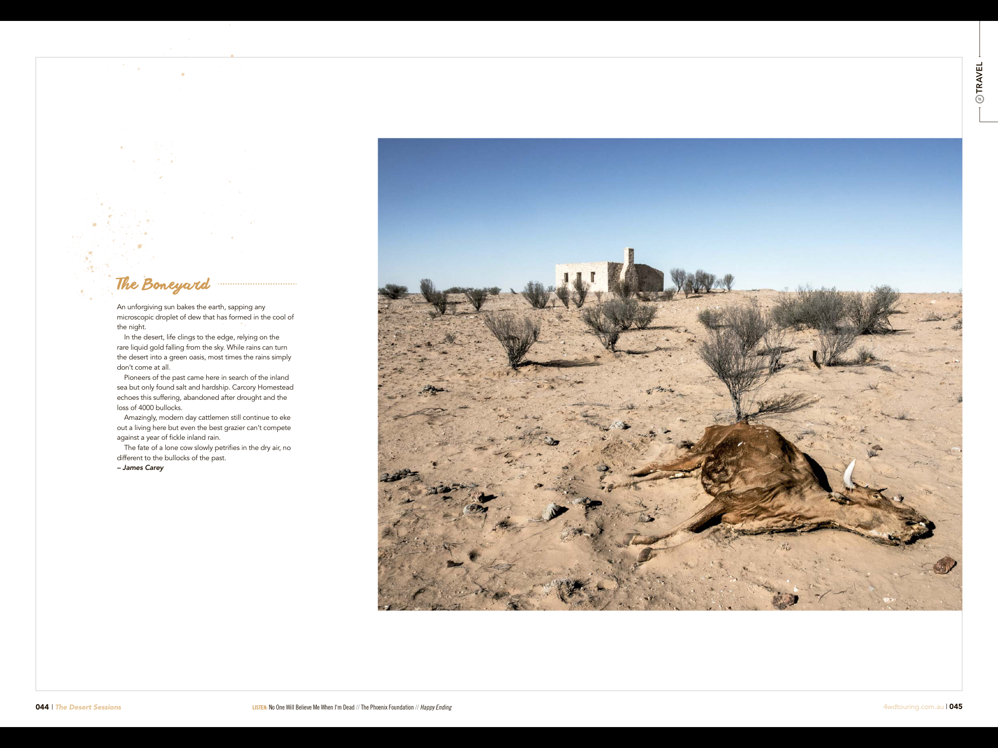
The Boneyard...
The outback can be unforgiving, no more so than in the desert. It is a landscape of extremes, the relentless sun baking the earth sapping any microscopic droplet of dew that manages to form in the cool of the night. Life clings to the edge relying on the rare liquid gold falling from the sky. While rains can turn the desert in to a green oasis, many times the rains do not come.
Pioneers of the past came here in search of the inland sea but only found hardship. Carcory Homestead echo’s this suffering, abandoned after drought and the loss of 4000 bullocks. Amazingly modern day cattle grazers continue to eke out a living but even the best farmer cant compete against the fickleness of the desert rains. This image is a reminder of the battle, the fate of a lone cow slowly petrifying in the dry air, no different to the bullocks of the past.

The Clock...
Our busy lives are bombarded with artificial lights and glowing screens. Day and night begin to loose their meaning. It does not take long for our bodies to separate from the natural circadian rhythms which recharge us each day. But camping in the desert changes all that. Waking to the rising sun re-synchronises the body clock. The body becomes more alert clearing the mind and regenerating the soul.
Whenever I camp I make the effort to face the rising sun. There are not many better views than slowly pealing back the zipper to see the day come to life.
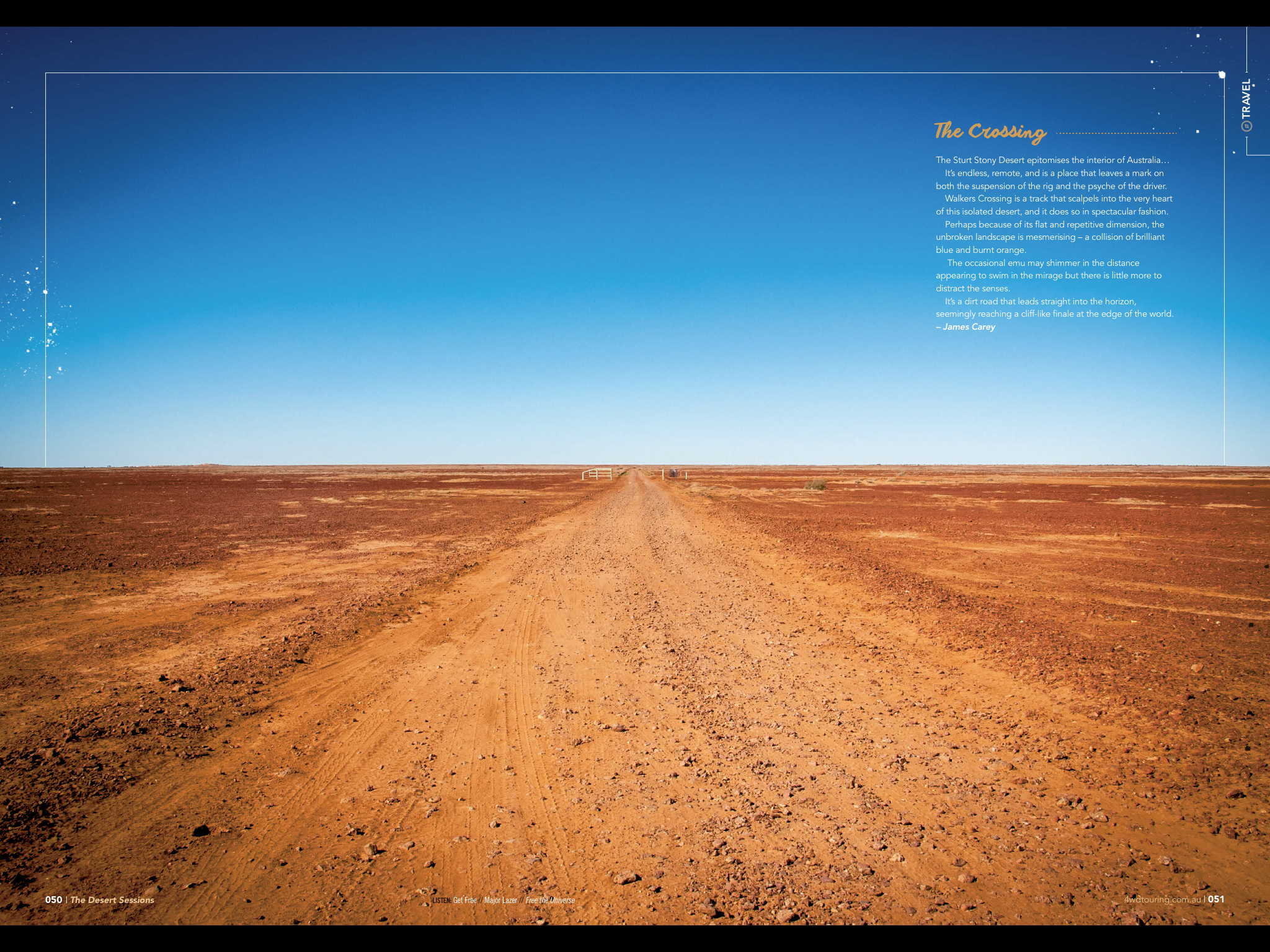
The Crossing...
The Sturt Stony Desert epitomises the interior of Australia. Stark. Endless. Remote. It is a place that leaves a mark on both car suspension and driver. Walkers Crossing is one of the few tracks which penetrates this isolated desert. Where blue meets burnt orange the dirt road leads to the horizon seemingly reaching a cliff like finale on the edge of the world.
Despite its flat repetitive dimension there is something mesmerising about this unbroken landscape. It is common to travel this path without ever seeing another vehicle. The occasional emu may shimmer in the distance appearing to swim in the mirage but there is little more to distract the senses.
Nonetheless, I would replace the noisy, chaotic, smog filled city roads with this track any day.

The Fire...
If there is one thing that goes hand in hand with camping in the desert, it is the campfire. While the days are warm, once the golden orb dips below the horizon it is time to get the campfire crackling to escape the night-time chill.
There is something in our genetics that has been carried over from our early ancestors that makes us gather around a fire. It is both a ritual and a necessity. When I camp with the family it becomes the central point to sit and have dinner and tell stories. Replacing the technology of city life with simple dancing flames keeps the kids entertained all night, marshmallows and sticks constantly being poked in to the depths.
When camping by yourself the campfire takes on a different meaning. It becomes your friend providing company, seemingly whispering to you and keeping the darkness ghosts at bay. Closing the eyes the warmth envelopes you, the flicker of the flames penetrating your eye lids.
This image was taken in Witjira National Park. I can still smell the Guinness stew, its wafts of herbs mixing with smoke as it drifts towards the darkness of the Simpson Desert.
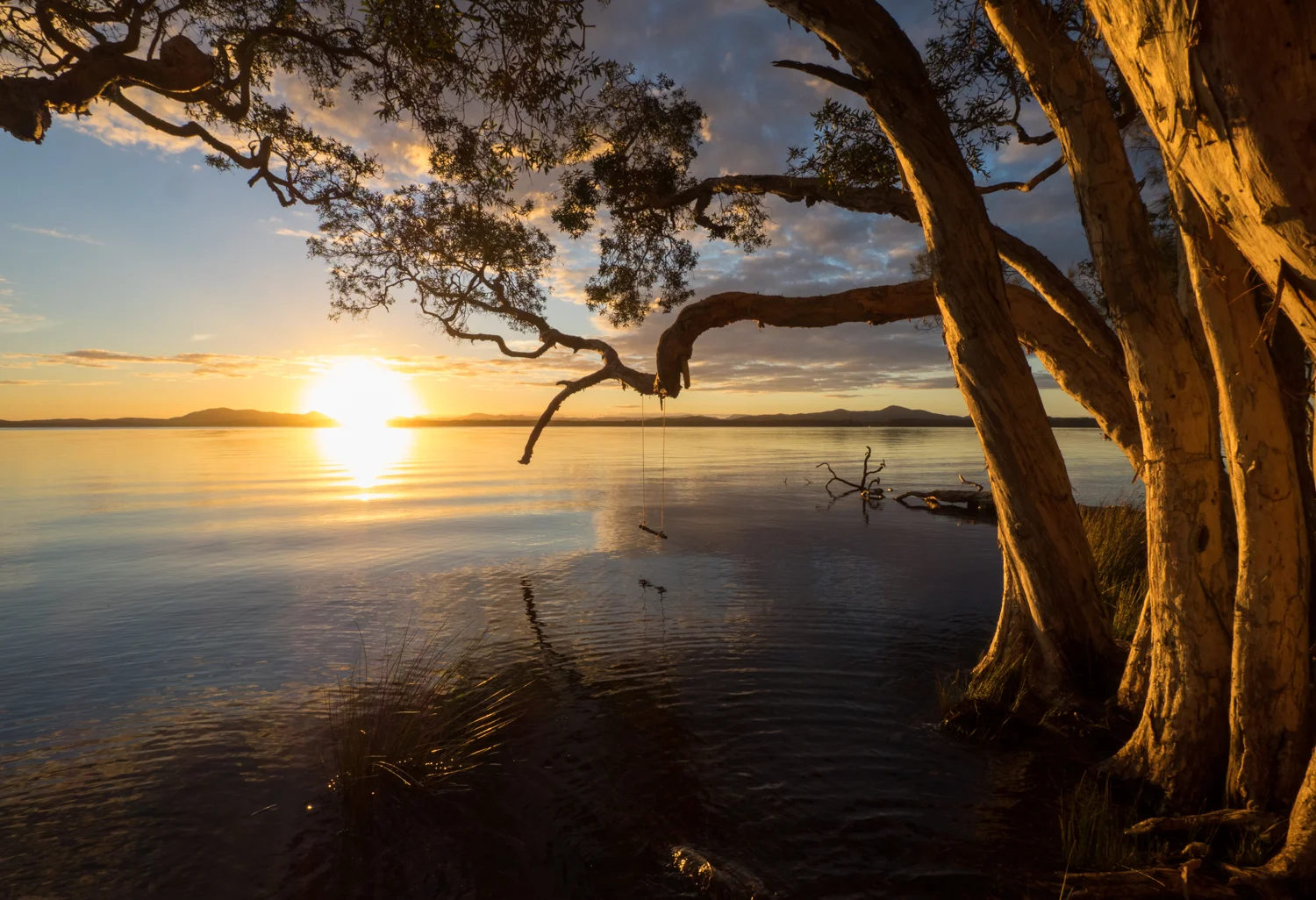
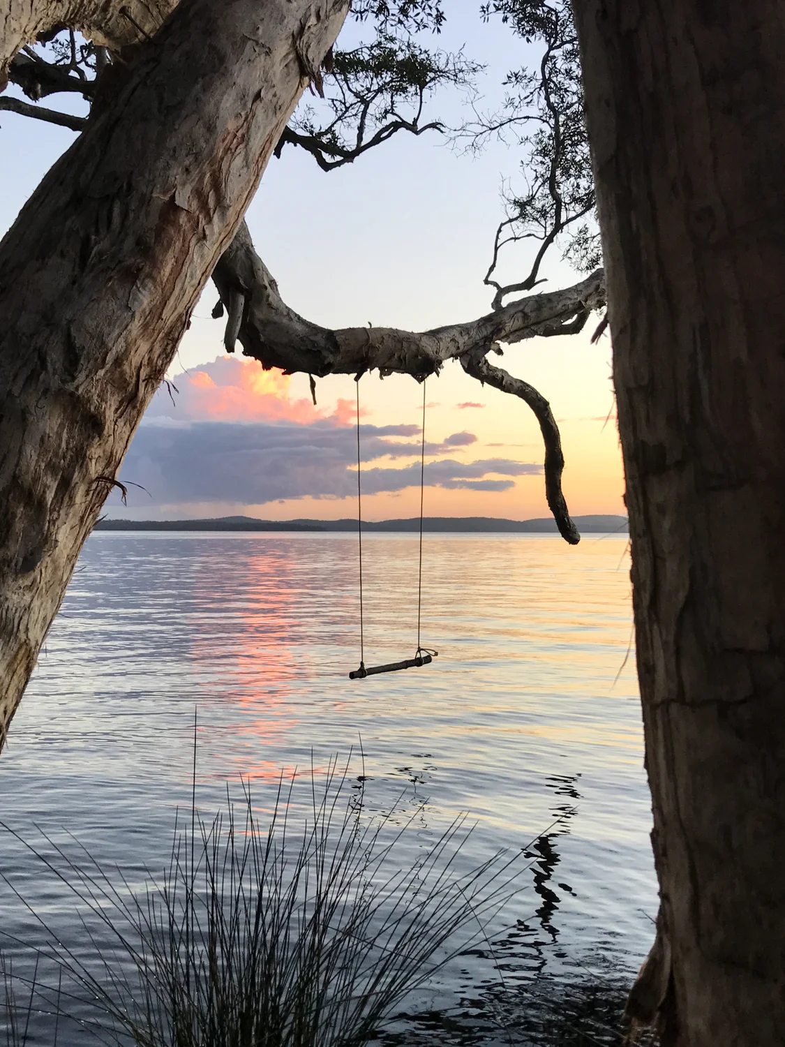
APRIL 2017: Myall Lakes, NSW
Another chance to take the lens on the road, this time to Myall Lakes north of Sydney. The National Park has the best of both worlds with one side a beautiful lake to spend the hours canoeing, while the other side has a beach with long whit sands ideal for 4WDing.
I was lucky enough to have some nice colours in the sky for some sunset images over the lake.


But even more fun was hitting the sand at Mungo Beach. It is the third longest beach in NSW with frequent big surf, high dunes and blowouts to the north. The beach is accessible at Mungo Brush but it was as soft as a marsh-mellow and chopped up following the easter weekend. so we headed for Sandy Point. At the headland is nice and protected, enough for the kids to safely swim.


A birds eye view of our 4wd's.


The afternoon we headed back to the lake for an evening kayak. and with views like this you would not want to be anywhere else.


The next day we spent some time exploring the adjacent Wallingat National Park. An easy 25km loop through the forest, the snow-white trunks of gum trees dwarfing the car. We headed for Whoota Whoota lookout with its scenic views of Wallis Lake, the forrest and coastline.


February 2017: Murrurundi on Horse Back
I was lucky enough to spend the weekend at Murrurundi photographing the amazing riders who participate in the King of the Ranges Stockman Challenge. A special thanks to the organisers who invited me along and allowed me to get some images of this great event.
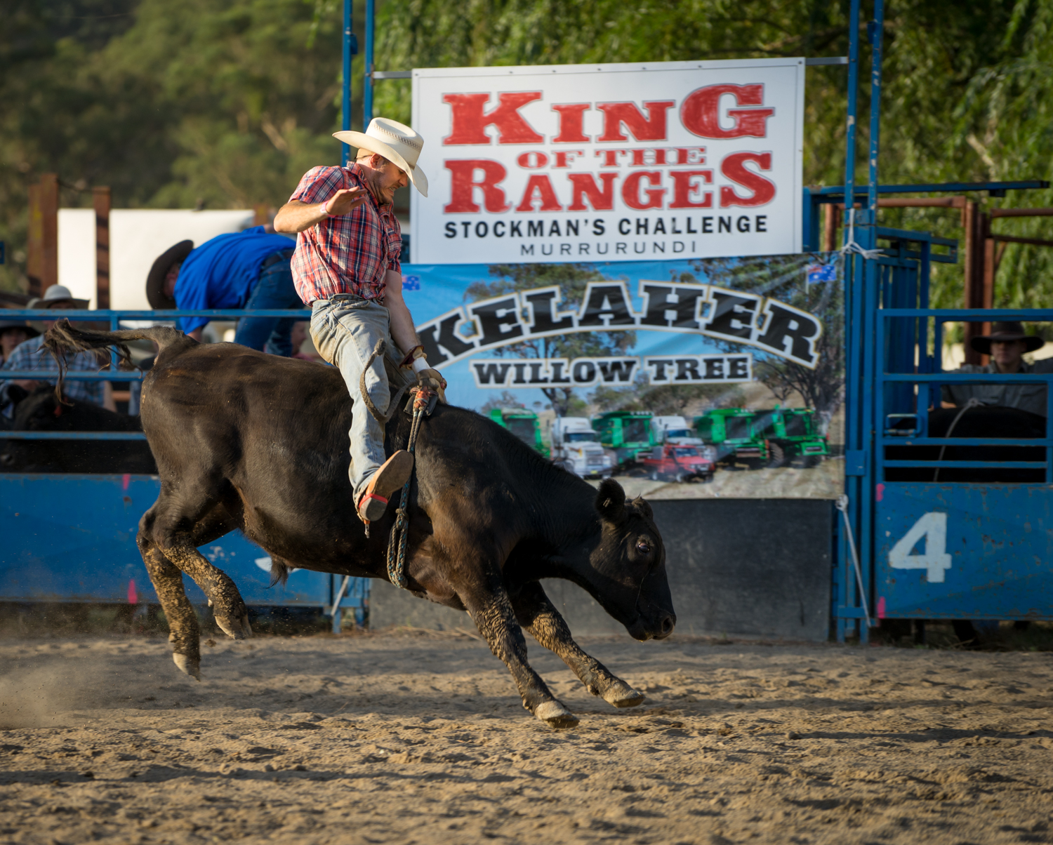


Bronson Macklinshaw demonstrated who was king of the range winning the event for the third year in a row. Over three days of tough competition he mastered horse shoeing, stock handling, whip cracking, cross country, a bareback obstacle challenge, saddle bronc and wild horse catch.


The cross country event.


Hold on tight.


Cowboys or Cowgirls. There are both to keep to interested.


These boots are made for walking (or should that be riding).


There was even some night time entertainment with the Bung McInnes Re enactment including members of the Murrurundi Light Horse as well as High Velocity Trick riding.


Even the dogs had a great time.


A bit of whip cracking to get morning started.


What a great way to spend the weekend


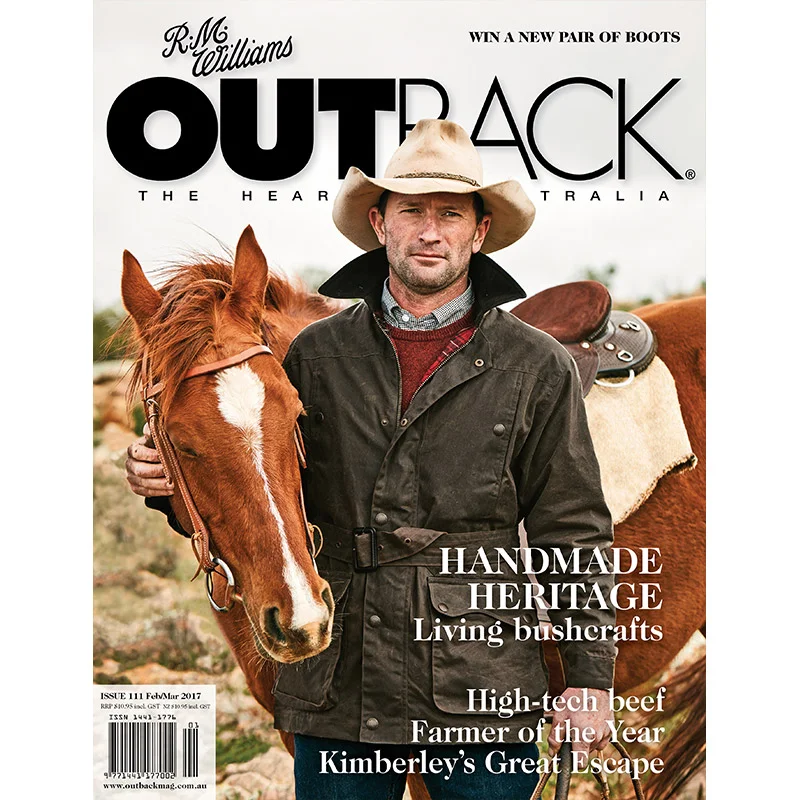
Pipe Dream
This story is an excerpt from Issue #111 of Outback Magazine: Feb/March 2017. To purchase a copy go to: https://www.outbackmag.com.au/shop/back-issues/

A 20-year vision has brought water to a long-dry lakebed in south-western New South Wales.
The gentle lap of water on the shore of Paika Lake is broken only by the chatter of the banded stilts, their long pink legs probing the muddy shallows searching for dinner. The recently planted native rushes and reeds sway in the fresh westerly breeze. This is a far cry from the arid dust-laden paddock that once stretched out in front of Dianne Williams, the owner of Paika station, as she contemplates the remarkable journey to get here. “There were times when locals would come up to me and say they have never seen water in the lake. I would quickly reply, ‘Well unless you are over 100 years old you wouldn’t have’,” Dianne says.
Paika Lake, Cherax Swamp, Hobblers Lake and surrounding wetlands are part of the Murrumbidgee River system in south-western New South Wales. In 1908 the lakes were disconnected from the Lowbidgee floodplain, when levees were constructed to concentrate water on the most productive land. Eventually Paika Lake and the surrounding wetlands dried up. As a consequence, “the health and diversity of plant and animal life dwindled, the river red gums that fringed the wetland had stunted or were near death, and the native seed bank was all but gone,” Dianne says.
In 1997 the Williams Family bought part of Paika Station. In the years that followed, drought was a constant reminder of how precious water was to the land. Dianne remembers when the dry lakebed was so fragile and could not be stocked for fear of losing all the soil. She says the westerly winds would swirl through the parched property, stripping it of life. “I remember years and years of shovelling buckets of dirt off the veranda,” she says.
Sue and Peter Morton, owners of the adjacent station, shared with Dianne a desire to restore water to the land. The Morton family has been farming for three generations in the area and Peter’s commitment to restoration started as a boy collecting bird eggs with his father. Little did he realise this hobby would one day result in him bringing thousands of birds to a lake that had been dry for more than a century.
To read the rest of the story purchase the magazine at: https://www.outbackmag.com.au/shop/back-issues/
A Lap of Van Dieman's Land
his story was covered in issue 59 of 4WD Touring Australia.

That little island at the bottom of Australia has been on the bucket list to explore for a long time. Finally we were able to escape the mainland and get a taste of what is has to offer.
Many long to take a year off and do a lap of Oz. For those that can’t spare the time the next best thing is to take a lap of a smaller heart shaped island at the bottom of the world. While Van Diemen’s Land was once a place of horrors for those that stepped on the wrong side of justice, today Tasmania is an ideal place to explore some of the National Parks it has to offer.
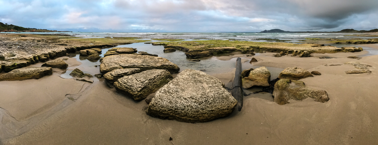
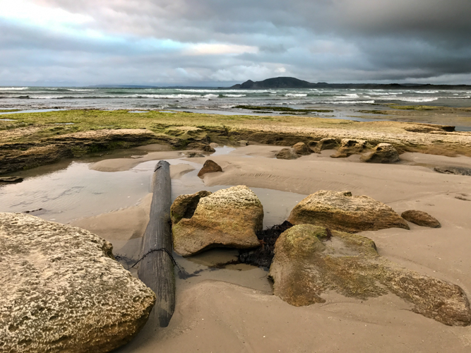
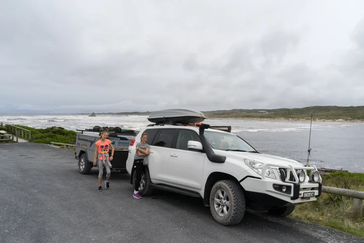
As a ‘mainlander’ we chose to take the car and camper on the Spirit of Tasmania. Departing the ferry we turn right in search of what the wild west coast has to offer. While many head for the popular towns of Strahan or Queenstown, the plan was to seek out the gravel road that weaves like a flowing river along the edge of the Tarkine rainforest. Wanting to make the most of the dirt we leave the highway at Smithton and head to Green Point Beach which overlooks the west tip towards Cape Grim. This small free grassy campsite is a popular spot for surfers who come to experience ocean swells that have travelled hundreds of kilometers over remote oceans before crashing in to the coast.
Not only do the ocean swells travel hundreds of kilometres before reaching the west coast, the ‘roaring forties’, build up momentum having left South America, creating a windswept and wild coastline as though sculptured by a madman with a chainsaw. It’s easy to see why a part of this coast is known as “The End of the World”.
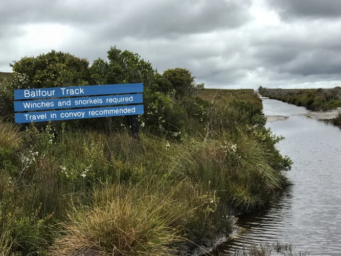
From Arthur River the road heads to the former mining settlement of Corinna. Known as the Western Explorer Road, this easy gravel road takes you along the edge of the Arthur Pieman Conservation Area. Arthur Pieman provides an ideal opportunity to lock the hubs with the Balfour Track the most famous, its 70 metre long canal-like stretch of water often requiring a submarine to get through. As the area is renowned for eating cars this one will have to wait for another time.
Arriving at Corinna, the wilderness retreat has some small but pleasant campsites strung out along the Pieman River. While there may not be any phone reception there is still the ability to get a cold beer at the old Tarkine Hotel.
Corrina is also famous for the Fatman. Not, the person behind the hotel, but the small barge big enough for our car and camper only, to cross the Pieman River.
We spend the next few days enjoying the fact that the kids electronic devices cant connect and explore the walking trails through rainforests with 1000 year old Huon Pines, their branches draped by fluorescent lime green moss.
While the west coast provides a taste of remoteness, we move on to Cradle Mountain National Park, proving an opportunity to don the walking boots and breath in the fresh mountain air. Many make the easy Dove Lake circular walk, while some tackle the famous 6 day overland track between Cradle Mountain and Lake St Claire. We opt for something in between with several long day walks through button grass moors and majestic mountain peaks covered with bursts of red and orange wildflowers like an English garden. The final climb to the summit of Cradle Mountain is only for the brave with vertical boulder hopping that leaves a passing walker trembling as they descend.


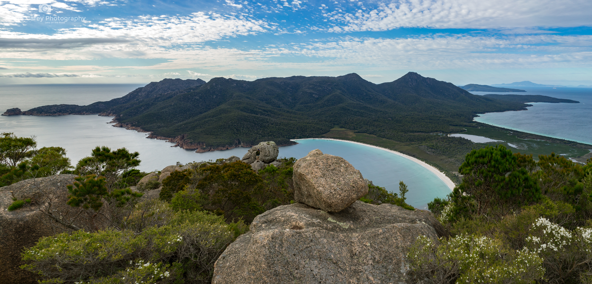
Continuing on the lap we make our way to Freycinet National Park. While not a place for off-road driving, the campsite perched on the edge of Great Oyster Bay makes the effort of bringing the camper trailer well worth it. While the popular walk to Wine Glass Bay Lookout gives you a taste of what the park has to offer, to truly experience its white sands, we continue on to the bay and Hazards Beach. The next morning we climb the harder Mount Amos to watch the morning light caress the bay. With adrenalin still pumping we hire Kayaks and slowly glide through the turquoise water exploring the inlets and little bays.
While weeks could be spent at Freycinet we have one more National Park to add to our list, this time continuing up the east coast to the Bay of Fires Conservation Area. While many think the name is due to the fire red and orange algae that covers the boulders, the name was actually given by Captain Tobias Furneaux, in 1773, when he noticed numerous fires along the coast.
Featured on many lists of the top 10 beaches in the World, it is hard to argue against its ranking especially when you can set up camp at one of the numerous free sites along the coast. Despite it being mid summer and the blue water and white sand passing for a tropical island, the cool waters are enough to keep us ‘mainlanders’ from anything more than a refreshing dip.


A few more days are spent exploring the dirt roads of Mount William National Park before completing our lap and returning on the Spirit. The early convicts dreaded the thought of being shipped to Van Diemen’s Land, but we look forward to our next sail across the Bass Straight in search of more dirt tracks and spectacular campsites.


January 2017: Tasmania's West Coast
Time to hit the road again, this time jumping on to the Spirit of Tasmania to the 'Apple Isle'. While we did not see too many apples we did get to explore some of the amazing natural scenery the island has to offer.
PART 1: WEST COAST


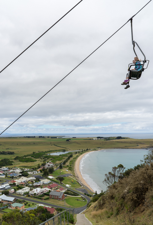
This post I will focus on the West Coast as we made our way from Devenport west. First stop Stanley, famous for the sheer-sided bluff called the Nut, the remains of an ancient volcanic plug. For the fit their is a steep but short waling track to the summit of the Nut, or you can take the chairlift.
From Stanley we continued to the coast following the less travelled Harcus River Road to Marrawah Green Point Campground. This small free grassy camp site is a stones throw to the beach.
From here we followed the to the 'Edge of the World'. Located at Arthur River, this certainly does feel like the end of the world with a wild, rugged coastline battered by the wild roaring forties.


From here it was a drive along the Arthur-Piemann Conservation area. Based on the car and trailer not being capable of being a submarine we bypassed the Balfour Track.


A few days were spent at Corinna, a historic town set in pristine rainforest on the banks of the Pieman River. Located on the edge of the Tarkine temperate rainforest, the area is famous for the Huon pine.


A Pub with No Beer
This story appeared in the October/November 2016 Issue of GoCamping. It is based on a trip along the Frome Downe Track in the Gammon Ranges, South Australia.
Much like Slim Dusty’s tune about the stockman who rides up to the local watering hole only to find “the pub has no beer”, we arrive at Waukaringa Hotel only to find it dry. This is not surprising, being the last remaining ruin from the original Waukaringa township of the 1880’s. Once a thriving mining town, the only other signs of an earlier life is the deep mine shafts, scattered bolts, and other workings discarded from settlers searching for the elusive yellow metal.
We arrive here to set up camp not long after leaving Yunta a small village near the NSW-South Australian Border that serves the passing travellers who rush along the Barrier Highway. Our goal was to leave the procession of cars and trucks and take the less worn path north along the Frome Down Track. From here we won’t see another sign of black tar until we reach Leigh Creek, over 500km away.
The Frome Down Track can be traversed by any standard 4WD making it a great alternative for those wanting to get away from the crowds. The lower part of the track is generally in reasonable condition due to local mines near by. Where yellow gold was once unearthed, this has been replaced with yellow cake as uranium is extracted from the ancient riverbeds.
While mining is still going on today, life as a miner in this isolated, parched land must have led many to drown their sorrows in the Waukaringa Hotel. Leaving camp, it is not long before we find another sign of the challenges of living on the land as we take a detour to the Erudina woolshed. With a series of good rain seasons in the late 1800, the government issued numerous pastoral leases. However Dorothea Mackellars poem could not be any truer as droughts quickly replaced the flooding rains. The woolshed is a reminder of the challenge of maintaining a head of sheep in this remote landscape.
From here the track meanders through Spinifex, tussock grass and gidgee woodland. The two small wheel ruts are lined with Sturts Desert Pea, much like Captain Charles Sturt recorded in 1844 " growing amid barrenness and decay, but its long runners were covered with flowers that gave a crimson tint to the ground". During this expedition Sturt and John McDouall Stuart explored the eastern shores of Lake Frome before turning north searching for an inland sea.
Much like Sturt and Stuart, we continue on our expedition following the edge of Lake Frome. While there is a rough 4WD track that heads out to the Lake we make our way to Balcononna in the Vulkathunka-Gammon Ranges. Having travelled through the flat vast plains, the rising Gammon Range erupts from the earth creating deep chasms and gorges carved by the rare river floods. A hike along the Weetootla Gorge is a great way to experience this geological museum of 800 million year old rocks twisted and deformed. What was once an inland sea has now been buckled and then eroded, providing an ideal home for the yellow-footed rock-wallaby.
Our camp for the next few days is an isolated spot next to one of the many dry river beds. If you want to have a break from the canvas there is the option of staying in Balcanoona Shearers Quarters or Grindells Hut built in the early 1850s. But the reason we travel these remote parts is to camp amongst the Coolabah Trees with the camp oven gurgling over the open camp fire.
North of Balcononna is Arkaroola which contains an extensive range of 4WD tracks. But we head west following part of the Wortupa 4WD Loop track. The full loop is 80km as you rise and fall over the range, each crest opening up to an epic panorama that would grace any Ken Duncan wall.
Heading further west, we exit the park and pass more reminders of the challenges of living on the land such as the Idninha and Yankaninna homestead ruins. While the early Europeans made hard work living here, the traditional custodians of the land, the Adnyamathanha People have continued to coexist. In 1998 the Nantawarrina Indigenous Protected Area, which covers 58,000 hectares of their land between the Gammon and Flinders Ranges, became the first indigenous protected area to be declared in the country.
Adnyamathanha means ‘rock’ or ‘hills’ people, and as we pass through the protected area the last glimpses of this rocky red escarpment disappears from the rear mirror. Eventually black tar reappears as we reach Leigh Creek, completing a 500km track that few travel. It must be time to find a hotel that serves beer.
Mutawintji Country
The following story appeared in Issue 51 of 4WD Touring Australia
For more images of our trip to this amazing place go to: Mutawintji National Park

While many of us look at this country as an observer of the land, water animals and plants, the traditional owners see ‘Kiirrakiirra’ or ‘Country’ with a deeper connection. Country is not only the landscape, but the stories, uses, kinship, and events intertwined with time, place and cultural relationships. It is this connection we seek at Mutawintji National Park in the corner of outback NSW.
Leaving Broken Hill, the flat plains of saltbush and mulga are unusually green and plump following the recent rains. It is a rare reprieve from what is normally a dry, dusty earth that glows and shimmers in a heat haze. There is little to slow down for except the regular road kill to allow time for the large wedge tail eagles to slowly take off like a lumbering fully loaded jumbo.
Eventually the tar is replaced with dirt as we head towards a small uplift that breaks the horizon. Here the Byngnano Range begins to rise as a red rocky outcrop exposing its 400 million year old sea-bed. It’s not long before we enter Mutawintji National Park, which lives up to its name as ‘place of green grass and waterholes’. We quickly set up camp at Homestead Creek, its flat grassy sites amongst the welcome shade of the River Red Gum trees making it an idyllic spot for the next few days.
This is the only place for permanent water between the Darling River and Coopers Creek, which made it an important stop for the horses in the early European journey from Broken Hill to White Cliffs. While rock rubble is the only thing that remains of the other watering hole – the Rockholes Hotel, it is a different cultural history we have come here to experience.
For the same reason early Europeans stopped at this sanctuary in an otherwise barren outback, it was a meeting place for ceremonies, trade and sharing of wisdom for the traditional custodians of this land. To develop a better understanding of this history we meet Mark to be taken on a walk through the restricted Mutawintji Historic Site. Mark is a Malyankapa man, and Mutawintji is his family's traditional lands.
We begin at the Mutawintji Cultural Centre and are quickly immersed in an audio-visual display that tells the Dreamtime story of Kuluwirru Ancestor God who lived in the sandstone caves of Nutharungee Hills and how he created Mutawintji. From here we are led up in to the rocky escarpment past native lemon grass, bush tucker and medicine plants to see his creation.
Entering the rocky overhangs the hand prints of traditional owners of the past seemingly wave from the dreamtime. Mark is a commanding man who’s imposing size is quickly replaced with a softer side as he quickly draws the children together under his wing giving them a unique privilege to get close and experience the rock art. With his hand pressed up against the ochre-stencilled cave wall, he re-enacts a tradition that has occurred for several hundred years.
There are many stories shared and many that are left to the imagination such as the references to Snakes Cave (a traditional men's initiation site) and Mushroom Rock (a traditional women's birthing site).
We cross the valley and wind our way up another escarpment to a point where the entire hillside has become a canvas of rock art etched in to the flat bedrock. Here emus, kangaroos, ceremonial headdresses, boomerangs, animal tracks and gods have been carefully carved into the stone. Only senior men were allowed to add to the hill and looking out from the top of the range it is easy to see why this place was chosen to sit and tell the Kuluwirru dreaming story.
Mark’s passion for country is equal with his enthusiasm to share the story of the historic action of the local community. What began in September 1983 with a blockade by about 100 local Wiimpatja and their supporters eventually resulted in Mutawintji becoming the first National Park in NSW to be handed back to Aboriginal owners. At the end of our tour Mark also hands us back with greater wisdom and knowledge allowing us to explore the rest of the park.
Having woken from a chilly -2 deg overnight we spend the next two days doing our own exploration of the 4 gorges that bisect the range each named after a colour of ochre. The Mutawintji Gorge Walk, Wester Ridge Walk and Rockholes Loop Walk all have taken on new meaning, connecting landscape stories, events and cultural relationships.
Exhausted, but feeling more connected, we sit by the fire for our last night, its glow creating shadows of the gum trees out across the dry river bed. As the ghostly shapes move in the crisp night air the words of Elizabeth Hunter, a traditional elder from the area, swirls between their leaves –
“Kaarukaya, yuna yuku ngaangkalaana kiirrinana, Paliirramarri kiirra, kiirrayi.”
“There is a place out in the west, and it’s the place that I love best”.
What to do
MUTAWINTJI GORGE WALK (6km) - a 3 hour return walk that leads you into the gorge, over rock boulders ending at a large rock pool surrounded by the red imposing cliffs.
WESTERN RIDGE WALK (6km) – departing from homestead creek camp this walk leads up the range past rock art and then traverses the ridge that overlooks the plains to the west.
ROCKHOLES LOOP WALK (4km) – This walk allows you to experience rock art and waterholes then up to the peak of the range with amazing outlooks before returning through narrow rock crevasses and down ravines with the assistance of rope.
OLD COACH ROAD DRIVE – While there are no difficult 4WD tracks in the park there is a nice 10km drive out to a walk to Split Rock.
MUTAWINTJI HISTORIC SITE – To protect this sensitive site it is only accessible with a guide.